Category:Rincon Mountains
Jump to navigation
Jump to search
mountain range in southern Arizona   | |||||
| Upload media | |||||
| Instance of | |||||
|---|---|---|---|---|---|
| Location |
| ||||
| Width |
| ||||
| Mountain range | |||||
| Highest point | |||||
| Elevation above sea level |
| ||||
 | |||||
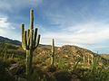
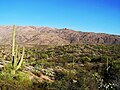
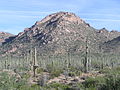
English: The en:Rincon Mountains on the east border of en:Tucson, Arizona of the Tucson Valley. The city of Tucson is at the north and northwest of the en:Madrean Sky Islands w:sky island region of southeast w:Arizona.
Subcategories
This category has the following 2 subcategories, out of 2 total.
M
- Mica Mountain (1 F)
R
- Rincon Peak (9 F)
Media in category "Rincon Mountains"
The following 18 files are in this category, out of 18 total.
-
 Bridal Wreath Falls in the Rincon Mountains.jpg 3,120 × 3,487; 7.75 MB
-
 Lenticular clouds over the Ricon Mountains (2427516907).jpg 3,008 × 2,000; 2.57 MB
-
 Mt. Lemmon Panorama.jpg 6,052 × 652; 1.59 MB
-
 Rincon Mountain Winter View.jpg 3,872 × 2,592; 4.57 MB
-
 Rincon Mountains.jpg 4,160 × 3,120; 5.03 MB
-
 Rincon-Mountains-AZ.jpg 14,425 × 1,234; 3.05 MB
-
 Saguaro National Park East.jpg 1,280 × 960; 833 KB
-
 Saguaro National Park P1013179.jpg 2,288 × 1,712; 849 KB
-
 Saguaro National Park P1013181.jpg 2,288 × 1,712; 866 KB
-
 Saguaro National Park-East map.png 1,844 × 995; 1.42 MB
-
 Saguaro National Park-situation map.png 1,143 × 650; 616 KB
-
 Saguaro National Park1935.jpg 1,800 × 1,239; 1.84 MB
-
 Saguaronationalparl17102008.jpg 2,048 × 1,536; 1.57 MB
-
 Snow in the Rincon Mountains (3728716076).jpg 1,024 × 207; 102 KB
-
 Sunset and Snow in the Rincon Mountains (3727913711).jpg 1,024 × 283; 160 KB
-
 Tucson az from space.jpg 1,370 × 760; 157 KB
-
 USA Region West relief Rincon Mountains location map.jpg 1,867 × 2,091; 1.05 MB
-
 USGS Map of Santa Rita and Patagonia Mts 1910.jpg 928 × 588; 280 KB

.jpg)


.jpg)
.jpg)